|
|||
| This
is a site of historical record and does not contain current service
information. Hendan síðan vísur gamlar tíðarætlanir og ikki tær ið eru galdandi nú. Denne side viser gamle køreplaner og ikke de aktuelle tider. |
|||
|
As the present day airport bus takes its passengers from Vágar to Tórshavn in less than an hour, few will realise that the capital was only linked by road to the rest of the island of Streymoy as late as 1966. The building of bridges and tunnels in the Faroe Islands over the past fifty or so years led to a natural expansion of the road and bus networks, but it also often meant the withdrawal of long standing ferry services.
As befits a mountainous island community with a population scattered in a succession of coastal towns and villages, the traditional means of communication was by boat and ferry, and this lasted until well after the second world war. To travel from island to island, or to reach the capital Tórshavn, you went by sea. And many and varied were the boats that served the islands over the years. The first Smiril provided regular mail boat services from 1896 throughout the islands, based at her home port of Tvøroyri in Suðuroy and called regularly at Tórshavn and Klaksvik as well as many smaller places. Travel to and from the capital was necessary for many reasons, be they official or to access the steamer to Denmark or Iceland, or for health reasons. Tuberculosis was a major problem in the islands and in 1908 a sanatorium was built at Hoydalar near Tórshavn, where people from all over the islands were brought; at the same time the first road built from the capital was to the sanatorium. Motor vehicles first came to the Faroes in 1922 and within a few years taxi operations had commenced in the capital Tórshavn, including links to Velbastaður and Kirkjubøur. The taxi association Havnar Bilfelag was formed by 1928, and in 1944 the Taxa association started; this latter becoming the p/f Taxa company in 1952, and subsequently p/f Auto in 1955. An early local bus operator in Tórshavn was Ole Arge, from 1944 running a few trips a day in a 20-seater between the town centre and Argir, the hospital, Sundsbrúnna and the sanatorium in Hoydalar. One of the significant
marine operators for many years was Mjólkaforsýningini (milk
producers, shown on the map below as 'Torshavn M & M Co.') whose
boat
'Sigmundur', the second of that name, covered the route from the
capital north to Eysturoy to Skálafjørður as well as along the east
coast of Streymoy to Sundalags and Hvalvik from 1950 to 1967. Carrying
mail,
passengers and goods, the ports of call on the complex route from
Tórshavn
included Toftir, Skáli, Strendur, Selatrað, Oyri, Streymnes,
Køllafjorður and Kaldbak (frequently the last call to collect fresh
milk
for the capital). These routes had started in 1908 with a small steamer
called 'Ruth', and 'Tróndur' and 'Streymur' served the route in the
1930s.
From 1962 to 1974 'Ternan' also assisted on
this route, with the boat's name being changed to 'Dúgvan' in
1970.
Taxi connections were available at Streymnes to Saksun and at Oyri to
Eiði. By 1967 a car ferry was in operation on the Tórshavn to
Toftir and Strendur route. |
|||
 |
|||
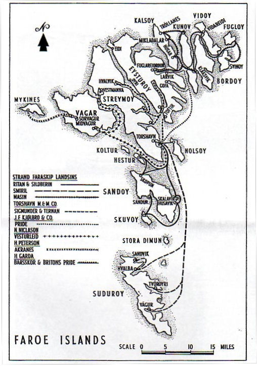
| Ferry routes in the Faroe Islands shown in
Gerald Daniel's 1966 map |
|||
|
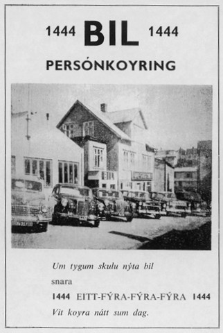
By the mid-1920s there were some individual stretches of roads on different islands. On Sandoy a road linked Skopun to Sandur and a bus or car route connnected with ferry arivals at Skopun. Other roads at this time included from Midvágur to Sorvágur on the island of Vágar; from Søldarfjørður to Leirvik and Fuglafjørður on Eysturoy (opened in 1927 and allowing easier connections between Tórshavn and Klaksvik); and from Køllafjorður to Kvivik on Streymoy. All of these roads had bus or car services from early days linking to and from the ferry sailings, and the latter road would be extended northwards to Hvalvik and westwards to Vestmanna in the 1950s. Finally in July 1966 it was linked to the new main road ('Oyggjavegur' = 'island road') which had been completed from the capital Tórshavn. But a comprehensive road network has only come comparatively recently to the Faroe Islands. Before the main road northwards from the capital was completed in 1966 a journey to the airport - which had been built by British forces during the second war and where commercial passenger flights had commenced in 1963 by the Icelandic airline Flugfélag Íslands - on the island of Vágar meant a choice of route. Either a boat trip all the way from Tórshavn to Midvágur, often a stormy ride around the headland Kirkjubønes in winter on the open deck ship 'Vesturleið', or alternatively taking a taxi from Tórshavn some miles northwards to the end of the uphill road constructed in 1959 to serve the NATO radar station at Mjørkadal, then clambering down the hillside with luggage to another taxi waiting near Signabøur on the road from Hvalvik and Køllafjorður to Vestmanna. This route was originally pioneered by the Bil (in 1963) and Auto (in 1964) taxi companies of Tórshavn who arranged the two hires - but you were on your own for the walk down (or up!) the hill at Hórisgøtu to bridge the gap. This missing link was aptly nicknamed 'Via Dolorosa' by travellers. Another alternative route (in pre-war years the boat to Vágar sailed from Kvivik) was by a bus connection from the landing places by Signabour (near Køllafjorður) where the Sundabrunna mail and milk boat from Tórshavn to the Sundini called. Once
the main roads were
connected throughout Streymoy from Tórshavn in 1966 several competing
car and bus
operations started to operate through journeys from the capital to the
newly linked towns and villages. But even before then taxi connections
were
being advertised in 1964 with change of vehicle at Hórisgøtu before the
road link was fully completed; as the construction of the
road progressed the gap to be walked grew less, with the final link
being made at a bridge over the Skeiðsá. Until built the bridge in this
section which still had to be walked on foot was known as 'Sukkenes
Bro', the bridge of sighs. In the
1968
timetable
'Oyggjarutan' (organised by the taxi firm Auto) linked Tórshavn to
Vestmanna, as did 'Bilrutan' (organised by taxi firm Bil). The
ferryboat ‘Olavur’ then linked
Vestmanna to
the landing place at Fútaklett on Vágar where another car or bus waited
for
the run to the airport. This crossing was subsequently shortened to the
landing place at Oyrargjógv on Vágar. As well as the Vestmanna
services other routes using the new road link ran northwards on the
coast road along the eastern shores of Streymoy, eventually providing
links across to Eysturoy.
There was some not inconsiderable duplication of times and mileage.
'Bilrutan' operated as far as Køllafjorður, Hósvík and Hvalvík;
'Oyggjarutan'
also ran to Hvalvík. From there a ferry crossing in either 'Litlaferja'
for Bil passengers or 'Sigmundur' for those travelling with Auto went
over to Oyri on Eysturoy and
then another bus or car onwards to Eiði (the Sundini road
bridge was not built until 1973). A third transport operator
'Bussrutan' (departing from taxi office Akstur Bil in Tórshavn)
similarly ran to Køllafjorður, Hósvík and Hvalvík in the 1968
timetable, continuing then to
the Streymoy villages of Saksun, Haldarsvík and Tjørnuvík. In the
1964 timetable there was no mention of 'Bussrutan' but instead there
was 'Streymoyarrutan' offering a service from Tórshavn to
Streymnes; Ole Arge the local city bus provider in Tórshavn is listed
as
the operator. |
 |
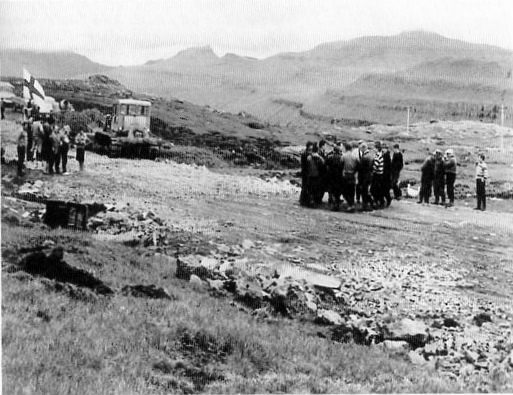
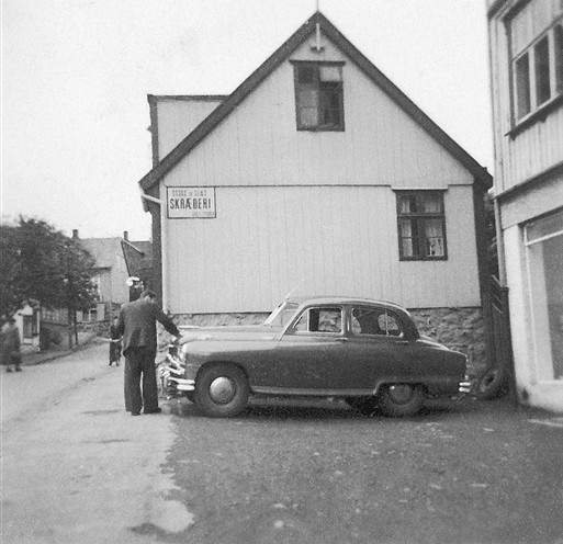
| The road to the airport (1) -
the start of the walk between the two roads at Hórisgøtu (Hóreksgøta)
in 1965 photo from the Bil of Tórshavn collection |
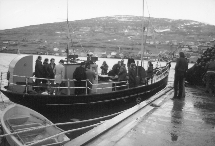 |
| The road to the
airport (2) -
ferryboat ‘Olavur’ which linked Vestmanna to Fútaklett photo from the Bil of Tórshavn collection |
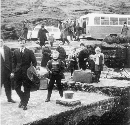 |
| The road to the airport (3) -
the landing place at Fútaklett on Vágar, with connecting bus to airport photo from the Bil of Tórshavn collection |
 |
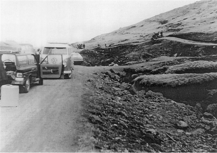
| The road to the airport (4) -
the missing gap in the main road completed on 6th July 1966. As the road construction advanced and the gap was reduced a connecting taxi or bus service was offered from at least 1964. photo Mikkjal Helmsdal |
|
Bil trace their
origins as taxi operators in Tórshavn back to
the 1950s, and the firm grew
from taxis and ambulances and school transport, then eventually to
buses on the new road links. Subsequently they became a main
bus contractor for the state-sponsored Bygdaleiðir bus network on the
routes from Tórshavn for some
twelve years or more, starting in 1980, including the route they had
served themselves since the mid-1960s to
Vestmanna. The Bil company was also the first contractor for the
Bussleiðin town buses in Tórshavn when they started running in 1979,
continuing until contract changes brought in other operators in
1983. Whilst
so far most of
the transport provision in earlier
years had been provided by (usually small) commercial operators, from
1980 onwards the government network of Bygdaleiðir country buses
started to develop and progessively assume the responsibility for
running the various routes, although the actual operation was most
often
sub-contracted to private operators. The 1981 timetable shows the
Bygdaleiðir routes on Streymoy as Tórshavn - Kvivik - Vestmanna,
Tórshavn - Kirkjubøur and Kvivik - Skæling. The Kirkjubøur route is
believed to have been the first to start. On the island of Sandoy the
Bygdaleiðir routes were from Skopun to Sand and Skálavik; Skopun to
Dalur and Húsavik; and to Skarvanes. The buses from Tórshavn to
Køllafjorður, Hvalvík, Saksun, Haldarsvík, Tjørnuvík, Eiði and Gjógv
remained privately operated for a few years more, as did those on
Eysturoy and the southern island of Suðuroy (the 1959 timetable shows
buses operating there regularly between the main towns of Tvøroyri and
Vágur, as well as to Fámjin and Sumba; earlier there had been coastal
boats, some of which were still operating until the early 1960s). Similarly
by 1977 virtually all of the boat and ferry services were under
governmnent control through Strandfaraskip Landsins. The timetable for
1981 showed that Teistin sailed
from Tórshavn to Suðuroy seven days a week, and also provided a direct
sailing to Klaksvik on Monday and Wednesday. Trondur went from Tórshavn
to Strendur and Toftir on Eysturoy, whilst Ternan sailed from Leirvik
to Klaksvik to round off the overland route. Barskor linked Kunoy and
Kalsoy to Klaksvik whilst Másin sailed from Hvannasund to the
northernmost isles of Svinoy and Fugloy. Ritan went from Tórshavn
to Nólsoy, Sandoy, Hestur and Koltur; and Sildberin onwards to Skúvoy
from Sand. Sam linked Vestmanna to Oyrargjógv on Vágar. An
earlier timetable from 1968 shows Strandfaraskip Landsins operating on
a smaller scale running Smiril (built 1932) to Suðuroy; the first
instance of government involvement in shipping had been the
taking over of the running of the first Smiril in 1917 on the Suðuroy
service. Ritan and Sildberin sailed to
Nólsoy, Sandoy and Skúvoy; with Másin serving the northern
islands. Private operators still ran the other links, notably to
Vágar, Eysturoy and the Sundini (see the 1966 map above) but time was
running out for most of the multi-stop local shipping services, as with
the development of the road network only the short point-to-point ferry
crossings would be needed in the future. |
 |
 |
|
| Bilstøðin taxi departure point in
Tórshavn in Niels Finsensgøta photo from the Bil of Tórshavn collection |
The 1960s Bil taxi fleet lined up in a
poster photo from the Bil of Tórshavn collection |
|
 |
||
| The ferry boat 'Litlaferja' photo from the Bil of Tórshavn collection |
||
|
|
 |
|
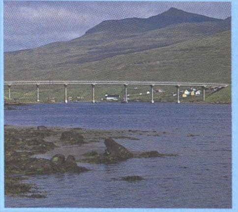
| Streymin
- the road bridge 'over the Atlantic' which opened in 1973 linking the islands of Streymoy and Eysturoy |
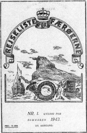
Cover of the wartime 1943 timetable
booklet - still published in Danish and not Faroese |
|
 |
||||||
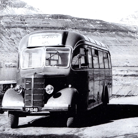
| Bedford
bus
of Sofus Joensen of Fuglafjørður who ran from there across Eysturoy via
Gøtu to Søldarfjørður for the boat to Tórshavn. This had been one of the first bus routes in the Faroe Islands. |
||||||
|
To travel
north from Tórshavn to the second city of Klaksvik there were
several options in the early 1970s, including a direct ferry once a day
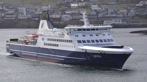
between the two towns operated by either the 'Smyril' or the 'Pride'.
Alternatively one could take the ferry 'Trondur' from Tórshavn across
to Toftir, and then by car or bus across the island of Eysturoy to
Leirvik followed
by another ferry journey on the 'Ternan' to finally reach the
northern town of Klaksvik. This bus route had been pioneered as
early as about 1925 but ran northwards to Fuglafjørður which was then
the main ferry port for
Klaksvik rather than Leirvik as in later years.
As 'capital' of the northern islands
Klaksvik on the island of Borðoy served as a secondary transport hub
for boats and ferries to
the nearer islands of Kalsoy, Kunoy and Viðoy, as well as to the other
more remote and distant islands of Fugloy and
Svínoy; the timetable for 1934 shows three vessels involved in that
work on different days, Immanuel, Guttaberg and Falken. |
||||||
 |
||||||
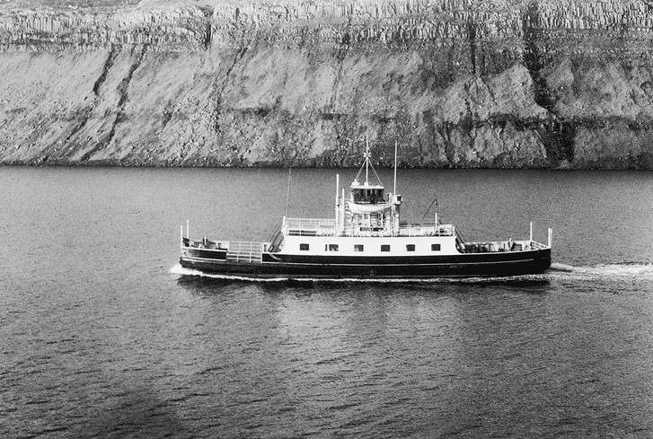
| The
ferry 'Sundaferjan' in the waters of Sundini photo from the Bil of Tórshavn collection |
||||||
|
Although the road
system on Streymoy was largely complete in the
mid-1960s there still remained at the time two distinct and separate
road systems
at either end of the island of Eysturoy. The opening of the 2.5
kilometre long tunnel in August 1976 between Oyrarbakki and Skálabotnur
connected these two former halves and led to a significant
restructuring of public transport routes, including those linking
Streymoy with Eysturoy. For a few years though after the Streymin
bridge had opened in 1973 an hourly vehicular ferry, appropriately
named
'Sundaferjan', continued to operate across Sundini from Hósvik to
Selatrað, but this ceased some time after the opening of the new road
tunnel. There were now through buses from Tórshavn across the new
bridge and through the new tunnel to the Eysturoy communities,
including Runavík and Toftir as well as Fuglafjørður and Leirvik for
the Klaksvik ferry.
The direct ferry route between Klaksvik and Tórshavn all but ceased and
the Tórshavn – Toftir and Strendur ferry became a peak-hour only
operation and then
was finally withdrawn altogether in 2002. |
||||||
 |
||||||
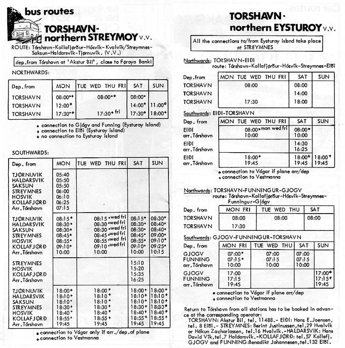
| Bus
timetable from the 1974 Faroes Travel
Guide, shortly after the opening of the Streymin bridge, with the
services on these routes provided by private operators working together. The state sponsored Bygdaleiðir bus network commenced in May 1980. |
||||||
|
On
the island of
Streymoy, to reach the village of Kaldbak (now part of the enlarged
Tórshavn municipality) in 1974, you still travelled on the daily
ferryboat 'Sildberin'. Now the journey takes less than thirty minutes
on the four or five times a day bus. The shipping service ended in 1980
when the road to Kaldbak was completed. In the northern islands, to
reach
Kunoy from Klaksvik meant catching the ferry 'Barskor'. Thanks to a new
causeway and a three kilometre road tunnel opened in 1998, the journey
is
now easily accomplished by bus. Change came for the island of Sandoy
too in the mid-1990s, with the longish ferry journey from Tórshavn to
Skopun replaced by a much shorter crossing from a newly constructed
landing place at Gamlaraett (which is served by the buses on the route
to Kirkjubøur). It was in the spring of 1993 that Gamlaraett was
brought into use. Tróndur was the first ship to sail this route, and
today Teistin sails the route. |
||||||
 |
||||||
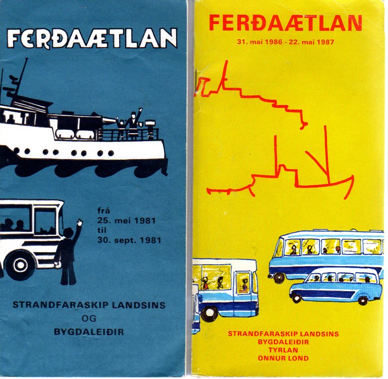
| Two
timetable covers from the 1980s for
the state sponsored bus and ferry network, with the 1986 timetable including inter-island helicopter flights (tyrlan) |
||||||
|
Now
the modern
day Faroe Islands have a fully integrated state-owned and heavily
subsidised transport system provided by Strandfaraskip
Landsins ferries and the blue country buses of Bygdaleiðir (the latter
was merged into Strandfaraskip in the 1990s). There are
through fares and through tickets, and the buses connect with each
other and with the ferries. As the tunnels and bridges expand, so do
the public transport opportunities. The 1993 road tunnel, 2.8
kilometres in length between Kaldbaksfjørður and Kollfjarðardalur, has
largely replaced the old upland Oyggjarvegur road (by way of Mjørkadal)
between Tórshavn and Vestmanna and has considerably shortened the
journey time to and from the airport and northern destinations. Another
tunnel was built to link Streymoy to the island of Vágar and now
through buses run to and from the airport. First proposed in 1989,
crossing from Leynar to near the old landing place at Fútaklett on
Vágar, this
tunnel was opened in December 2002 and led to the demise of the ferry
service between Vestmanna and Oyrargjógv on Vágar. Whilst this was good
for both the island and airport travellers it has put Vágar, like
Eysturoy, within daily commuting distance of the capital. But in
counterbalance perhaps it will lessen the risk of depopulation from the
settlements in these islands. The Vágar tunnel was the
first built under the sea in the Faroe Islands, so as the
Streymin bridge is known locally as the bridge over the Atlantic,
perhaps this will become known as the tunnel under the Atlantic?
With acknowledgement to the research and publications of Mikkjal Helmsdal 1916 - 1996. With many thanks to Bil of Tórshavn for
the use
of their
pictures This
article is still in development and
further information,
clarification or corrections are welcomed.
|
||||||
Føroyar Upplýsing um bussar og ferja í Føroyar - eg eri takksamur fyri hjálp tina. |
||||||
|
||||||